The Office of Homelessness Prevention and Intervention has made improvements with a new position and will adopt new recommendations from the Mayor's Task Force on Homelessness
In 2023, the Urban County Council adopted a Complete Streets Policy. This policy aims to create new design standards and regulations for Lexington’s streets to ensure that they are safe for all residents moving in Lexington.
Complete Streets is a term used to describe a street that is safe for all people traveling on it, whether they are traveling on foot, by bike, by the bus, or by car.
As part of the policy, a Complete Street Action Plan was developed to set target dates for certain actionable tasks to be completed by. Tasks in the action plan vary widely from hiring new staff positions to focus on Complete Streets projects, developing marketing and communications strategies, and updating the City’s street design manuals to create new standards and regulations to prioritize safety for all users.
Nationwide, cities are reevaluating urban transportation. Since the 1950s, transportation networks have primarily been planned in order to move cars quickly. Other modes of transportation, including walking, bicycling, and public transportation, were deprioritized.
As planning car transportation has been prioritized, car-related deaths have grown steadily — and since 2020, they have grown rapidly. Car infrastructure is also expensive to maintain; In the Mayor’s proposed budget for Fiscal Year 2026, $14 million alone is allocated for repaving roadways.
Increased traffic deaths, expensive infrastructure costs, environmental concerns, and more factors have led to US cities exploring ways to design for other modes of transportation besides cars, and Lexington is no exception.
Why do Complete Streets Matter?
2023 was a peak year for bicycle and pedestrian deaths in Lexington: there were 180 collisions where a car hit a bicyclist or a pedestrian, with 22 of those resulting in deaths. 37 of those were hit and runs.
While 2023 was a particularly dangerous year for bicyclists and pedestrians on Lexington roadways, this is not a new problem. In 2014, the Lexington Herald-Leader reported that Lexington had 143 pedestrians hit by drivers, and had 16 pedestrians killed by drivers from 2011 to 2014.
There are several possible explanations for why deaths have risen so sharply, but many attribute street design for fast vehicle transportation as the root cause.
Road designed to move cars fast can include higher speed limits, straight roads, and wider/more lanes.
While this can make car-based transportation faster, it can also make roads more dangerous for road users. Studies show that the chance of a fatality in a car accident can double for each10 mphincrease in vehicle speed.
But, it can be especially deadly for vulnerable road users like pedestrians, cyclists, and motorcycle users.
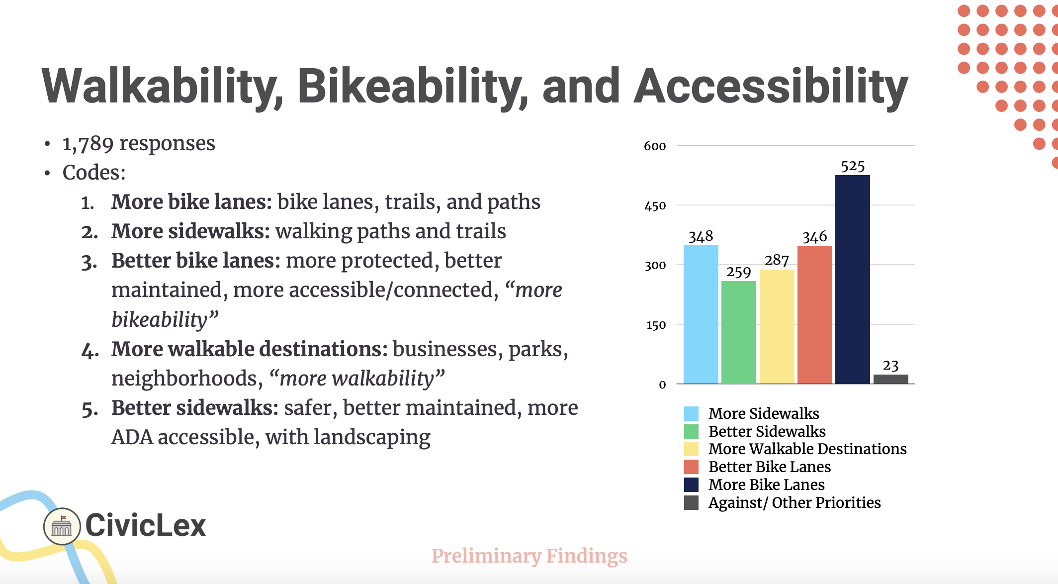
In our On the Table community survey data, the most discussed issue was Bikeability, Walkability, and Accessibility. Of the over 15,000 individual responses, 1,789 people mentioned this topic.
How can you get involved in Complete Streets?
If you want to get engaged in issues around Complete Streets, there several city Boards and Commissions working on the issue whose meetings you can attend, or that you could join!
What else do I need to know about Complete Streets?
Complete Streets Policy and Action Plan
In 2023, the Urban County Council adopted a Complete Streets Policy. This policy aims to create new design standards and regulations for Lexington’s streets to ensure that they are safe for road users, including cyclists, pedestrians, transit riders, and drivers.
As part of the policy, a Complete Street Action Plan was developed to set target dates for certain actionable tasks to be completed by. Tasks in the action plan vary widely from hiring new staff positions to focus on Complete Streets projects, developing marketing and communications strategies, and updating the City’s street design manuals to create new standards and regulations to prioritize safety for all users.
Some action items scheduled to be completed by 2025 include:
Adopt a Vision Zero Policy to establish a goal of having zero roadway deaths or serious injuries by 2050 (Completed)
“Vision Zero” is a phrase used for cities setting a goal to reach zero roadway deaths.
Create two staff positions, a Complete Streets Manager and Vision Zero Coordinator (Completed)
Establish a safety committee or work group to develop and implement Complete Streets safety projects
Create public webpages to show efforts and work being done, including the status of Action Plan Tasks and data from Complete Streets and Vision Zero performance.
A Complete Streets Design Manual will also be completed in 2025. This Design Manual will set regulations for how Lexington's streets will be built to accommodate all users.
Developers constructing new streets as part of a project will have to follow this manual.
When LFUCG repaves or does construction on a road, they will redesign and rebuild the road in accordance with the manual.
Major Complete Streets Projects in Lexington
The City of Lexington has completed and is pursuing many Complete Streets projects to redesign Lexington's roadways. Here are some notable projects that have been completed or are in-progress:
Rethink Parking
In October 2022, Council voted to passed Rethink Parking, a zoning ordinance text amendment (ZOTA) that changed many of Lexington's parking lot regulations.
Notably, Rethink Parking abolished parking minimums in Lexington. Parking minimums are regulations that require developers to add a certain number of car parking spaces to their developments.
A common parking minimum you will see in other cities is requiring 1 car parking spot per bedroom in an apartment complex.
As well as abolishing parking minimums, the ZOTA passed by Council also set landscaping and design regulations for parking lots. These aim to make sure that parking lots are safe to walk through for pedestrians, and that there are enough trees and plants in the parking lot to create shade that lowers temperatures and supports the local environment.
Lots with 15+ spaces, or lots over 5k square feet, must use trees and plants to create an internal parking network by separating spaces and controlling traffic flow; this prevents cars from driving through rows of parking spots as a shortcut to a businesses entrance or exit.
When a developer chooses to provide parking spots for cars, they must also provide bike parking. Bike racks must be in well-lit, secure places near the entrance to any new building.
Town Branch Commons is a two-mile shared-use path that moves through the heart of downtown Lexington along Midland Avenue and Vine Street. Eventually, it will connect to the Town Branch Trail via the upcoming Gatton Park on the Town Branch. You can learn more about Town Branch Commons here.
STREEET Safety Task Force
The STREEET Safety Task Force (Shared Travel Requires Engineering, Education, and Enforcement of Traffic) was created in January 2025 by Vice Mayor Dan Wu. The STREEET Safety Task Force aims to address immediate issues and needs regarding safety for all modes of transportation in Fayette County.
The Task Force complements Lexington’s Complete Streets Action Plan, which sets long-term policies for how to improve and redesign Lexington streets. However, the STREEET Safety Task Force will focus on current and immediate gaps not addressed by the Complete Streets Action Plan.
Examples of these include "quick-build" installations that can calm traffic, such as placing a large flower pot in and intersection to create a roundabout, using crosswalk art to bring drivers' attention to a crosswalk they may otherwise miss, etc.
The Task Force is co-chaired by District 10 Councilmember Dave Sevigny and District 5 Councilmember Liz Sheehan and includes other Councilmembers, representatives from Public Safety, Planning, Engineering, the County Attorney’s office, and the community.
Campus to Commons
Campus to Commons is a recently completed plan that proposes a new design focused on bicycle and pedestrian improvements along Virginia Avenue, Red Mile Road, and Forbes Road from UK’s campus to the new Turner Commons development. No funding has been allocated for construction of any portion of the project as of July 2025.
Connect East Lex is a recently completed plan for the design of a bike trail connector between the Brighton Rail Trail in Hamburg and the Legacy Trail and Town Branch Commons downtown. No funding has been allocated for construction of any portion of the project as of July 2025.
Imagine New Circle Road is a project that redesigns the portion of New Circle Road from Newtown Pike to Richmond Road to be safer for bicyclists and pedestrians.